Lesser Antilles: general information. Greater Antilles. Lesser Antilles
In 1992, Derek Walcott, after being awarded Nobel Prize in literature, gave a lecture on the topic “Antilles: fragments of epic memory.”
For him, the archipelago on which he spent his life became a symbol of poetry itself, because poetry is “an island that breaks away from the mainland.”
The Antilles were named after a ghostly island, put on the map by sailors at the dawn of the Age of Discovery.
The Venetian cartographer Giovanni Pizzigano drew it on his nautical map in 1424, which was lost over time.
In 1946, this Italian portolan was discovered in one of the archives.
Pizzigano ventured to mark on it not only the Azores, which were discovered a few years after the creation of the map, but also the mythical island of Antila.
Antilles: ghost island
The Portuguese legend of the Seven Cities of Gold tells of the pious bishops of the Visigothic kingdom, who in the 8th century could not come to terms with the conquest of the Iberian Peninsula by the Moors and set sail across the Atlantic Ocean. 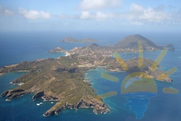
When their caravels landed on the island, they landed and founded a city near each of the seven bays.
Since Antilia was believed to be shaped like a mirror image of the Kingdom of Portugal, it was called Opposite Island, or Island of the Other (Ante-Ilha).
The medieval name did not catch on immediately.
British author Gavin Menzies, in his book “1421 – the Year China Discovered the World,” claims that the mythical Antilia is the island of Puerto Rico.
Geography and population
For some time, the Spanish conquistadors preferred to call the archipelago discovered by Columbus the Windward Islands, since they are washed from the southwest by the waves of the Gulf of Mexico and the Caribbean Sea, and from the northeast they are open to all winds Atlantic Ocean.
Later this name stuck to the group volcanic islands archipelago.
Cuba, Haiti, Jamaica, Cayman Islands, Puerto Rico - all these are the Greater Antilles, by their geological origin they belong to mainland North America, although culturally they are much closer to Latin.
The Lesser Antilles were created by volcanoes and the formation of coral reefs, they are usually divided into three groups:
- Leeward Islands in the South
- Windward Islands in the north
- Windward Antilles to the west.
If The population of the Lesser Antilles is about 3.7 million people, then 10 times more people live on Bolshaya – 90% of the archipelago’s population.
Political system, language, religion
Many islands remain colonies of France, Great Britain and the Netherlands to this day; a number of islands are under US administration. 
Puerto Rico is not formally part of the United States, being a freely acceded state, while The Cayman Islands are considered British overseas territories. and this means that the current form of government there remains a constitutional monarchy.
In the Antilles you can hear Spanish, English, French and Creole, as well as many different dialects.
The majority of the population of Cuba, Haiti and Puerto Rico are Catholics.
In Jamaica, 24% of people identify themselves with the Church of God of Prophecy, and in the Cayman Islands, most people attend the Anglican Church.
Sights of the Lesser Antilles
Antigua Island
Crescent Bay, which is located on the southeast coast of the island of Antigua, in the parish of St. Philip, is considered the embodiment of the pristine beauty of the Caribbean islands. 
Les Saintes Islands
The French islands of Les Saintes, 16 km from Guadeloupe, are inhabited by the descendants of blue-eyed Breton colonists. 
Terre de Haut Island
Fort Napoleon is still preserved on the island of Terre-de-Haut, and the town offers many bars and cafes.
Montserrat Island
The British island of Montserrat attracts bird and volcano lovers. In its forests you can see about 34 species of birds, and in December a real carnival begins on the island.
Nevis Island
Nevis is famous for being visited by Admiral Nelson in his youth. In Charlestown today you can see many historical buildings in the style of colonial architecture of the 18th - 19th centuries.
There is a park in the center of the island.
Barbados Island
The island of Barbados invites you to travel around underwater world on the Atlantis submarines.
Many colorful fish, the remains of real shipwrecks and a certificate of diving depth attract those who like to tell others about their adventures.
Turks and Caicos Island
Turks and Caicos Island is famous not only for its preserved 1852 Grand Turk Lighthouse, but also for its shellfish farm.
Curacao Island
The historic bay of the Dutch island of Curacao attracts most tourists to Willemstad. 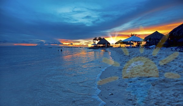
The island is also located national park Sint Christoffel, which is home to white-tailed deer, and the Shete-Boka Nature Reserve, where you can see pink flamingos.
Aruba Island
The island of Aruba is famous for Arikok National Park and Guadiriki Cave, where some of the oldest rock paintings of the Arawaks have been preserved, as well as exotic vegetation and diving conditions. 
Jamaica: Paradise for Rastafarians
The island belongs to the British Antilles.
Tourists are attracted by the opportunity to visit plantations, ancient estates, a sugar factory, as well as TuffGong Studios and Bob Marley's home. 
A special attraction was also created on the island in honor of the Jamaican bobsled team from the film “Tight Turns”.
In Kingston, people traditionally visit the Devon Creole estate and botanical gardens, where you can see exotic flowers that are somewhat reminiscent of lobsters.
Ocho Rios has Shaw Park and Coyaba Rover Gardens.
The colonial gardens of Castleton, north of the Antilles capital, and Quinchon in the Blue Mountains were formerly used for the sale of seedlings.
The best beaches on the island are:
- Negril
- Frenchman's Cove Beach in Port Antonio
- Doctor Cave beach in Montego Bay
- UDC and Reggae in Ocho Rios.
- Seastar Inn and Catcha Falling Star Gardens
- Tryall Club in Sandy Bay
- Jamaica Inn in Ocho Rios
- Geejam in Port Antonio
- Iberostar Grand Rose Hall
- Sandals Royal Plantation.
Colonial Baroque and Revolutionary Museums in Cuba
Time stopped in Cuba twice - after 1898, when Spanish rule ended, and after the revolution of 1959.
On this island you can see relics of two eras, in the first of them everything happens as tourists imagined:
- graffiti by Che Guevara with the slogan “Socialism or Death”;
- American cars that disappeared back in the 60s;
- house-museum of Hemingway Finca Vigia, where "The Old Man and the Sea" was written.
In an earlier era, everything is different - the historical center of colonial Havana with its:
- Embankment
- Capitol
- fortress of La Cabana
- cathedral,
was included in the list World Heritage UNESCO.
Not far from Playa Giron beach there are cenotes, limestone lagoons that connect to the sea.
On the Zapata Peninsula you can visit the Cave of Fishes.
Cuba is known for its beaches, but visitors to the island are offered a taste of the special atmosphere of its cities, which may soon change forever.
Most of the island's hotels remain state-owned, but recently new hotels have been built.
Top hotels:
- Paradisus (Varadero)
- CasaIvettey Ronel (Girona beach)
- Iberostar Grand (Trinidad)
- Saratoga (Havana).
Heavenly Citadel of Haiti
After the earthquake in January 2010, many expected to see only ruins on the site of Haiti, but its effects are most noticeable in the capital, Port-au-Prince.
If you climb from the Sans Souci Palace to the walls of the La Ferrière citadel, located on the top of the mountain, you can look over the Northern mountain range, and sometimes see the coast of Cuba.
The citadel was built by the first king of Haiti and is considered the largest fortress in the Western Hemisphere.
Tourists prefer to stay in Pétionville, a suburb of Port-au-Prince, where a hotel from the BestWesternPremier series was built.
At the top of Mount Boutilier, whose height is 1000 m, there is an observatory. You can book a boat excursion near Labadi port.
Hotels:
- Royal Caribbean International
- Cormier Plage Beach Resort
- Cyvadier (Jacmel)
- The Inn at Villa Bambou (Port-au-Prince)
- Abaka Bay Resort.
Puerto Rico: The Rum Diary
This island is sometimes called the 51st US state.
Puerto Rico is considered the birthplace of the Pina Colada cocktail for a reason - it is a country where, according to the novel by Hunter S. Thompson, a bottle of rum costs a dollar, and ice costs two. 
The Caribe Hilton hotel, where the drink was invented, appeared on the pages of the Rum Diary, the film adaptation of which starred Johnny Depp.
The historic part of San Juan, with its cobbled streets and colorful colonial-style buildings, is protected by UNESCO.
Ruta Panoramica is Puerto Rico's most famous mountain road that winds its way across the island past the beaches of Rincon, Cabo Rojo and the Arecibo Observatory in the Antilles, home to the largest single aperture radio telescope in the world.
In the south of the island, you can visit the port city of Ponce, whose architecture shows traces of the influence of ArtNouveau and ArtDeco styles, and the Museum of Art houses a collection of Pre-Raphaelite works, in particular paintings by Frederic Leighton and Edward Burne-Jones.
Hotels:
- El Convento (San Juan)
- El Conquistador
- Ramada Ponce
- Casa Isleña.
Video tour of the island of Barbados
Did you like the article?
Subscribe to site updates via RSS, or stay tuned for updates
Antilles (Spanish: Antillas), an archipelago in the West Indies: the Greater Antilles (Cuba, Haiti, Jamaica, Puerto Rico) and the Lesser Antilles (Virgin, Windward, Leeward, Trinidad, Tobago and Barbados).
The total area of the Antilles is about 220 thousand km². The population of the Antilles is about 30 million people. Height up to 3175 m. Yes active volcanoes. Deciduous and evergreen tropical forests are widespread.
The following states are located in the Antilles: Antigua and Barbuda, Barbados, Haiti, Grenada, Dominica, Dominican Republic, Cuba, Saint Vincent and the Grenadines, Saint Lucia, Saint Kitts and Nevis, Trinidad and Tobago, Jamaica, as well as US possessions , Great Britain, France, the Netherlands, part of the territory of Venezuela.
The Netherlands Antilles (Dutch Niderlandse Antillen) are a possession of the Netherlands in the West Indies, part of the Leeward Islands (the islands of Curaçao, Bonaire, Saba, St. Eustacius) and the southern part of the island of Saint Martin in the Windward Islands.
The total area of ownership is 800 km². The population is 194 thousand people (1992), mainly blacks and mulattoes. Official language in the Antilles - Dutch, Papiamento (a Creole mixture of Spanish and Portuguese), English and spanish languages. The administrative center of the property is Willemstad on the island of Curacao. Willemstad and its suburbs are home to most of the Antill population - 140 thousand people. Of the believers, 85% are Catholics, the rest are Protestants.
Since 1954, the Antilles have enjoyed internal autonomy. The Dutch governor is the personal representative of the Queen of the Netherlands. Questions foreign policy and defense are the competence of the Dutch authorities. The Antilles Legislative Assembly regulates matters of internal government and is elected by popular vote for a term of four years. Executive branch carried out by the governor with the help of the Advisory Council and the Council of Ministers headed by the Prime Minister. Each island has local authorities - lieutenant governors, councils and governments.
The Antilles were discovered by the Spaniards at the end of the fifteenth century. In the thirties of the seventeenth century, the Dutch appeared on the islands. But only in 1816, after decades of stubborn struggle with Spain, France and England, the Antilles were assigned to the Netherlands. Slavery was abolished on the islands in 1863. Until 1986, the Netherlands Antilles included the island of Aruba.
The most important sector of the Antilles economy is tourism . 28% of the islands' amateur population is engaged in serving foreign guests. The Antilles are visited annually by over a million tourists, mainly from Western Europe and North America. 75% of tourists stop on the island of Saint Martin. The oil refinery in Curacao is of exceptional importance for the Antill economy. It runs on imported oil. There are three transit oil terminals on the islands of Curacao, Bonaire and St. Eustacius. One of the largest dry docks in America, capable of receiving ships with a displacement of up to 155 thousand tons, operates in Curacao. Antillas have enterprises in the pulp and paper, textile, food, tobacco and alcoholic beverage industries. Here they assemble electronic equipment and extract salt. Favorable conditions have been created on the islands for the activities of foreign capital. For ten years, foreign enterprises are exempt from paying taxes. The development of agriculture in the Antilles is hampered by a lack of fresh water; only 5% of the islands' territory is cultivated. IN agriculture Only 1% of the self-employed population is employed. Aloe (on the island of Bonaire), sorghum, legumes, tropical fruits and vegetables are grown. Most of food is imported, and a significant part of Antilla's exports are petroleum products. Antill's main foreign trade partners: USA, Netherlands, UK. There are international airports on the islands of Curacao, Bonaire and Saint Martin. The unemployment rate in the Antilles reaches 30% of the economically active population. The monetary unit is the Dutch Antillean guilder (florin), equal to one hundred cents.
In 1493, Columbus discovered the island of Saint Martin. Curaçao and Aruba were discovered in 1499 and were under Spanish rule. At the beginning of the 17th century. The Dutch captured the islands of Aruba and Bonaire, and in 1634 Curacao, which became the center of the slave trade. Since 1627, the Antilles have been a colony of the Netherlands. In 1954, the colony was declared an overseas part of the Netherlands.
Holidays on the beautiful Antilles, located in the Caribbean Sea off the coast of the American continent, are very popular among wealthy clients, for example, rich Americans who are accustomed to an exquisite vacation. Today, Russians can also discover part of the Antilles archipelago - the islands of Aruba, Guadeloupe, Martinique, Saint Barthelemy and Saint Martin, but you’ve probably heard about Curacao yourself...
In the Middle Ages, portolans - ancient maps of the world used by sailors - depicted Antilia, an island in the Atlantic Ocean, west of Portugal. Judging by its size and rectangular shape, the island was almost a mirror copy of Portugal itself. The sailors never discovered Antilia, but this ghost island gave its name to an entire archipelago located thousands of kilometers from Europe, in
At the end of the 15th century, at the very beginning, the expedition crossed the Atlantic and discovered previously unknown shores. Mistaking the newly discovered lands for the legendary Antilia, the researchers gave them the name Antilles.
The archipelago forms a vast semicircle, located between South and North America and washed by the waters of the Caribbean Sea and the neighboring one. It is divided into two large groups - the Greater and Lesser Antilles. The former include Haiti, Cuba, Puerto Rico and Jamaica. The second includes about 50 small islands that form an arc connecting Trinidad and Puerto Rico.
The Greater Antilles are fragmented fragments of the mainland. Most of the territory of each of them is occupied by mountain systems. Almost all of Jamaica and southern Puerto Rico are occupied by plateaus and block mountains, and in Haiti four ridges stretch in the meridional direction, which cut through longitudinal fault valleys. The exception is Cuba, where two-kilometer-high mountains border only the southeastern coast, while the rest of the island is occupied by a low-lying plain.
The Lesser Antilles are of biogenic and atoll) and volcanic origin. In the central part of many of them (Dominique, Saint Vincent, Martinique, Guadeloupe and others) there are extinct or active volcanoes, bordered by lowlands that form the products of eruptions. The coastline of the archipelago is highly indented and very picturesque due to the abundance of alternating capes and bays, as well as ancient and modern coral reefs.
The Lesser Antilles include the possessions of France, Great Britain and Venezuela, in addition, there is a separate group - the Netherlands Antilles, consisting of two subgroups. These are the islands of Bonaire, Aruba and Curacao, located in the south of the archipelago, off the coast of Venezuela, and the islands of Saint Martin, Saba and Saint Eustatius, located almost a thousand kilometers to the north.
The archipelago has a difficult and tragic history, which has left its mark on the culture of every state located in the Caribbean. Pirate romanticism and the tragedy of the colonial past are closely intertwined here, and sonorous names The islands are reminiscent of the glorious era of great discoveries.
Now the Antilles are one of the most popular tourism destinations. The blooming nature of the tropics, the azure waters of the ocean, traces of ancient civilizations and the spirit of freedom that has survived centuries later attracts people from all over the planet. Each island has a distinct personality, each state has its own unique symbols. Haiti is famous for its active recreation, Jamaica for its reggae rhythms, Martinique for its elite cane rum, Barbados for its marvelous orchids, Cuba for its colorful carnivals and rich nightlife, and Saint Martin - culinary arts.
The life of the archipelago has long been inextricably linked with the ocean. And in the modern tourism industry, marine entertainment plays an important role. Their choice here is simply huge: diving to coral gardens, underwater caves and wrecks, snorkeling, cruises on sailing yachts, trips on a submarine with fishing in the ocean, excursions to uninhabited islands. There are also opportunities for cliff diving, surfing, kite and windsurfing and deep water solo (rock climbing over the sea without insurance).
Also interesting are land excursions dedicated to the colonial and pirate past, as well as modern culture and the luxurious nature of the archipelago.
"Paradise islands" - this is what the discoverer of these places, the great navigator Christopher Columbus, called these lands. Great sea depths are adjacent to elevations that, literally “emerging” to the surface from the azure water, form large and small islands, with coral reefs, sharp volcanic rocks and beaches with white and black sand. The western "outskirts" of the Atlantic Ocean - this is also the name of these islands, located between North and South America. Dozens of small islands in the Caribbean Sea have a geographical name - the Lesser Antilles, and several large ones - the Greater Antilles, respectively. We can talk endlessly about the beauty of the Caribbean. It is a real riot of colors with an incredible number of shades of green. Rainforests and impenetrable jungles, orchids, magnolias, begonias, ferns, groves of coconut and banana palms, sugar cane plantations, various spices, coffee... And all this is observed by a piercing blue sky with textured cumulus clouds, running at the call of the strong sea wind.
The natural conditions of the Caribbean islands are truly magnificent. This is a tropical zone with a warm and humid climate that varies little throughout the year. Due to the strong sea breeze, the heat is not felt. Constant temperatures air (+27) and water (+24), attract many tourists here all year round, mainly from Europe and the USA. (
Paradise Islands, Alexander Zamyshlyaev, Around the World.)The Antilles lie between North and South America and form, as it were, a fragmented continuation of the mainland. From the Gulf of Paria at the mouth of the Orinoco to the Strait of Florida, they stretch over 13 degrees of latitude and border the Gulf of Mexico and the Antilles (Caribbean) Sea in a huge circle. Taken together, they form an area of 228,662 square meters. km with a population of 4,333,942 hours. They are divided into two main groups: the Greater and Lesser Antilles. The first include 4 islands: Cuba, San Domingo, or Haiti, Jamaica and Portorico; of these, the first two and the last (the smallest) form an almost straight line, heading from the western corner of Cuba to the Yucatan Peninsula. The Lesser Antilles, numbering about 50, lie between 10-19° north. latitude and form an arc starting from the island of Trinidad and abutting the eastern corner of Portorico. Seven of them contain strong volcanoes, and on the eastern side of each of these seven islands there is a series of calcareous islets. In general, the A. islands give the impression of a mountain chain, torn by the Atlantic, Caribbean and Mexican seas, the isolated peaks of which protrude above the water. The highest of these peaks are: Sierra Mestra (2375 m) and Sierra del Cobre (2119 m) in Cuba and the Blue Mountains (2370 m) in Jamaica.
The Small A. Islands, depending on whether the northeastern trade winds reach them earlier or later, are divided into “Windward Islands” and “Leeward Islands.” But there is no unanimity in this nomenclature. The British and French call them southern, as well as eastern. the branch from Tabogo to Dominic is the Windward Islands (Iles-du-vent), while the islands lying from Dominic to Portorico are the Leeward Islands (Iles sous le vent). The Spaniards give the first name (Islas-barlo-vento) to all the Lesser A. islands from Portorico to Tabogo, and the second name (Islas-soto-vento) they, and after them some geographers, assigned to those islands that are scattered along the northern coast S. America to W. from Trinidad to Oruba (before the Gulf of Maracaib). The sea wind softens the hot climate of these islands. The sky here is amazingly clear, the soil is unusually rich. In April and May, at midday, spring rains fall for half an hour or a whole hour, accompanied by wind. The main rainy period occurs in August and October, with the thermometer reaching 45° C. The sea here is amazingly clean; the ebb and flow of the tide is barely noticeable. Almost all of these islands suffer from earthquakes and hurricanes. Heat and dampness make the climate very unhealthy, and for the same reasons neither wood nor metals are durable here. Coffee, sugar cane and tobacco grow in incredible quantities and form the main subjects of agriculture and trade. The name of these islands "Antilles" was first mentioned in 1493 by Peter Martyr d'Anguiers, but the origin of this word is unknown. Some believe that this name comes from the island "Antilia", which the legend of the end of the Middle Ages placed on the Eastern Ocean, while others are of the opinion that the Antilles mean coastal islands, that is, those that lie in front of the mainland of America. The Lesser A. Islands are sometimes also called the Caribbean Islands. Together with the Bahamas, which lie to the north of A. between San Domingo and Florida, the Greater and Lesser A. islands are known as common name West Indies. ().
Map of the Antilles (source - Around the World)
Map of the Lesser Antilles (English)
Map of the Greater Antilles (English)
Antilles (Dutch)
Located in the Caribbean Sea. These include 6 islands in the Lesser Antilles archipelago: Aruba, Bonaire, Curacao, Saba, Sint Eustatius and the southern part of Saint Martin. Total area - 1011 sq. km. Population - 245.5 thousand (1978), ch. arr. blacks and mulattoes. Adm. center - Willemstad (65 thousand, on the island of Curacao). The official language is Dutch. English and Spanish are widely used. The local Papiamen dialect is widespread. Most of the population are Catholics (87%).
The islands were discovered by the Spaniards at the end of the 15th century. During the period 1630-40. were occupied by the Dutch, then repeatedly occupied by the Spaniards, British and French. They finally passed to the Netherlands in 1816. In 1863, slavery was abolished on the islands. Since 1954 - a self-governing part of the Kingdom of the Netherlands, enjoying autonomy in internal affairs. Issues of external relations and defense are the competence of the metropolis. In 1975, negotiations began between the Antillean and Dutch governments on granting independence to the Antilles. In 1978, the Royal Labor Group was created, which should give recommendations regarding the future by the end of 1980! about the state island devices
The head of the territory is the Queen of the Netherlands, represented by the governor. Legislative power is exercised by a unicameral parliament (22 deputies), elected for 4 years. Executive power is exercised by the governor and the government - the Council of Ministers. The government appoints a minister plenipotentiary in The Hague.
The internal political situation on the islands continues to remain tense, largely due to the lack of unity among the main political parties on the issue of granting independence. In the early elections to the parliament of the former UP in 1979, the Movement for New Atillas party won. (1 seats). It was created in 1971 in Curacao and advocates democratization political system islands, their state integrity and for greater independence in matters of self-government. Party for the electoral movement of the people (5 seats) - created in 1973 on the island of Aruba, advocates secession from the Antilles in 1981, the proclamation of its independence. Democratic Party (3 seats) - created in 1945 on the island of Curacao, advocates granting independence to the islands, against the collapse of a single state. In 1973, as a result of a split in the party, the Social Democratic Party was formed. National People's Party of Curacao (2 seats) - created in 1949, advocates close ties with the Netherlands, for the “systematic” preparation of the islands for independence. People's Party of Aruba (2 seats) - advocates giving the island a special status. Patriotic Party of Aruba (1st place) - created in 1949, advocates self-determination of the island based on the independence of each of the islands. The Patriotic Union of Bonaire and the Democratic Party of the Windward Islands received one seat each. The Labor Front Party was created in 1969 and demands independence for the islands. Trade union organizations: General Union of Trade Unions of Curacao, Christian Union of Curacao, Federation of Trade Unions of Aruba and Antillean Confederation of Workers' Unions.
The country's economy is in a state of deep crisis, manifested in a reduction in production (including in the oil refining industry), a decrease in investment in the manufacturing sector, and an increase in unemployment.
The oil refining industry is the basis of the economy. It employs 5.1% of the amateur population. In 1978, St. 45 million g of petroleum products. The oil refining industry belongs to the Anglo-Dutch and American monopolies. The plants run on imported oil, mostly from Venezuela. In 1978, 54 thousand tons of phosphates were extracted, 480 thousand tons of salt, 1.5 billion kWh of electricity, 12 million cubic meters of fresh water were obtained. The textile industry occupies a significant place. There is a dry dock in Curacao - the largest on the American continent, capable of receiving ships with a displacement of up to 120 thousand tons.
Due to lack of fresh water, he sat down. the economy is poorly developed. It employs 2.8% of the amateur population. Most of the food is imported. In 1978, the gross grain harvest amounted to 7 thousand tons. The number of cattle was 8 thousand, pigs - 6 thousand, goats - 21 thousand, sheep - 8 thousand, poultry - 61 thousand. Tourism is one of the main sources of income (in 1978 - about 400 thousand tourists). There are 7 airfields, of which 4 are international, 9 ports serving sea lines. The tonnage of the maritime merchant and passenger fleet is 164.6 thousand. t. The length of roads is 1183 km.
The currency is the Dutch Antillean guilder. 1.80 ant. guld.= 1 am. dollars (1979). The basis of foreign trade is oil and petroleum products (95% of the value of exports). Characteristic feature is a chronic foreign trade deficit. balance.
In 1977 it amounted to 867 million ant. Gould. Main foreign trade partners: Venezuela, Argentina, Brazil, USA, EEC countries, Japan.
The Antillean government creates favorable conditions for foreigners. investments. Established enterprises are exempt from paying taxes for a period of 10 years. A consequence of foreign domination. monopolies are mass unemployment, inflation, rising prices. In 1978, unemployment reached a record level (approx. 30% of the working population). There is a constant increase in the cost of living (in 1975 = 100, in 1978 = 115.4).
Sources:
- Countries of the world: Brief political economics. reference book.-M.: Politizdat, 1980, 497 p.
- Small Atlas of the World / senior ed. N.M. Terekhov-M.: GUGK, 1980, 147 p.


