Freezing causes the Nile. Abnormal weather events
When preparing this article, about 200 thousand dated events were processed.
CHRONOLOGY OF THE LITTLE ICE AGE
In my database there are 240 historical evidence of cold snaps from 355 to
1953, but of greatest interest are 20 certificates of
freezing of the southern seas - the Black, Adriatic and Mediterranean, as well as
the Nile Delta, the ice-free soda lake Van (Khlatskoye Sea) and
Bosphorus. Here is a list of these events.
401 years The waves of the Black Sea “hardened”
557-558 year. The Black Sea is covered with ice
608 The sea is covered with ice
696 The Khlatskoe Sea is frozen
739 Frozen Bosphorus
741-742. “The Pontic Sea is frozen by 30 cubits”
762-763 year. Part of the sea turned to stone 30 cubits deep
763-764 year. The Black Sea is completely frozen
801-802. The Black Sea is frozen
829 Ice bound the Nile Delta
859 The Adriatic Sea is frozen
1010-1011. The Black Sea, the Bosphorus, the lower reaches of the Nile River are frozen
1210-1211. The Adriatic Sea is frozen
1233 The Adriatic Sea is frozen
1326 The Mediterranean Sea is completely frozen
1454 The Yellow Sea froze 20 km from the coast
1601 The Black Sea is frozen
1709 The Adriatic Sea is covered with “standing ice”
1754 Canals frozen in Venice, ice in the Black Sea straits
1874 Frozen Bosphorus
Three cases of freezing in the Baltic and four cases of freezing in the northern part
The Black Sea, if not excessively severe, is not included in the list.
It is worth noting that during the “volcanic winter” of 1816, when
the average temperature on the planet fell by 1 degree, in the chronicles of the fact
the freezing of the southern seas is not reflected. Therefore, in the above
During winter, the temperature on the planet dropped even lower, deep into the region of the Small
Ice Age.
The problem is that the chronicle information contradicts scientific data. 16
of the 20 winters (80%) in which freezing of the southern seas is documented -
outside the Little Ice Age, in the so-called. in "temperature"
optimum." The trends in the graph show how the cooling developed in
Little Ice Age (gray diamonds) according to glaciology data, and how it should
would develop if we rely on the dates of historical evidence (black
line). There is a conflict.
Not long ago, the Intergovernmental Group became involved in this conflict
experts on climate change (IPCC), who changed their position to
time from 1990 to 2001 from the recognition of the medieval
climate optimum to non-recognition. Otherwise save traditional
historical dating is no longer possible.
GENERAL STATISTICS OF CATACLYSMS
To show the situation with chronicled cataclysms, I will give a general
statistics. 14 types analyzed natural disasters and 1
humanitarian (repression of sorcerers and Jews, closely related to the fall
volcanic ash, fires and epidemics) from 1st to 2012th year.
NAME OF CATACLYSM NUMBER OF EVIDENCE
Passage of comets 559
Earthquakes 519
Major fires 633
Hurricanes and storms 448
Repression of minorities 946
Volcanic eruptions 776
Tsunamis and floods 340
Mass psychoses 341
Epidemics 690
Cold weather 186
Crop failure and famine 271
Unusual precipitation 166
Signs (electromagnetic phenomena) 141
Heat and drought 132
Falling ash or smoke 108
TOTAL: 6256
726 years free from disasters. The remaining 1286 years account for 6256
certificates - on average 4.9 certificates per year. Trend
the distribution of evidence shows 106 catastrophic periods,
each of which lasts, on average, 12 years and contains, on average, 59
evidence of disasters. Break between catastrophic periods
lasts about 7 years. Roughly speaking, 2000 years consist of 106 cycles of 19
years (lunar cycle), of which 7 years are good, and 12 are
a complete disaster, often caused by the fall of “fire from the sky” and carrying
universal character.
It is reasonable to assume that in fact major disasters were significantly
less. Thus, Professor Schaeffer in his work on comparative
stratigraphy Bronze Age in the Middle East (1948) indicates
only six layers containing traces of the fall of fire - baked earth and
glassy masses.
It is clear that if such a catastrophe is truly large, it can
awaken volcanoes and provoke a whole set of accompanying, closely
related disasters. An earthquake causes a tsunami, an eruption causes a fall
ash, smoke in the atmosphere - further cooling, and cooling -
crop failure and famine. Moreover, all these disasters must occur nearby
one with the other, and therefore have a clear chronological connection in the chronicles.
Let's check its availability.
CHRONOLOGICAL CONNECTION OF CATACLYSMS
Here is an example of the chronological connection between eruptions and floods (tsunamis):
most of them tend to occur simultaneously, in the same year.
At a distance of 1-3 years from the historical eruption, the number of written
evidence of tsunamis or floods is declining sharply, and this
Fine.
And here is a graph with 225 combinations of 15 main types of disasters,
expressed as a percentage. Branches of the graph located below the 100% level
indicate the propensity of two different types of historical catastrophes
happen in one year. It is worth stepping back a year from the date of the cataclysm
or back, and there may not be a pair cataclysm, and the percentage is below a hundred
this process of coincidence reduction reflects. 181 out of 225 couples (80%) behave this way.
The database contains quite a lot of local events, for example, Atlantic
hurricanes of the 20th century. It is clear that local cataclysms such a graphic
connections will not be shown: it is unlikely that an earthquake in Tajikistan will cause a tsunami in
Philippines. And the graph clearly says that the lion's share of chronicled troubles
this is not a local event, but a multiple reflection of multi-component
disasters.
Of course, there are exceptions that indicate the tendency of some couples
disasters occur at a distance of about a year. So, the cold snap does not occur
simultaneously with the release of volcanic ash into the atmosphere, and approximately
in a year. There are 44 such exceptions, which clearly indicate the dynamics of the process.
out of 225, that is, about 20%.
CALENDAR CONNECTION OF CATACLYSMS
No less interesting is the tendency of cataclysms different types happen in
the same month of the year and even on the same days of the month. On the chart
below, the 365 days of the year are divided into 13 lunar months, and the correlation is obvious.
Of course, the connection between tsunamis and earthquakes is obvious even without graphs, however
Only 74 tsunamis are directly associated with earthquakes in the chronicles.
Another 222 tsunamis and floods were attributed to earthquakes hundreds of years ago.
An equally obvious calendar connection is shown by the chronicle fires and
hurricanes. The August-September anomaly is an annual seasonal hurricane
Caribbean, not related to global disasters, but
other storms and hurricanes noticeably gravitate towards fires.
Sometimes the connection between hurricanes and fire is very direct. So in l. m. 6210 hurricane
accompanied the fall of the “fiery hail” that boiled the sea, and the storm of 1164
years in Frisia led not only to the flooding of the entire coastal land, but also
caused massive fires. The same happened in Lisbon in 1755, in Japan in
1923 and in Moscow in 1451, 1493, 1547 and 1737. Occasionally
At the same time, the earth and stones burn.
Below you can clearly see the calendar relationship between fires and unusual precipitation,
and, I must say, fires blazing simultaneously with the downpour in my
there are only four bases. All other strictly correlated fires and precipitation
separated in the existing chronology by centuries.
841 For three nights the fire appeared. It began to rain, removing the bark from the trees and knocking down stones.
1783 After the eruption of Laki (Iceland), acid precipitation was recorded on Crete
1453 The entire city was washed away (?) by thick fog. When the fog cleared, “flames engulfed the dome of Hagia Sophia.”
Here is the most interesting case: the connection between eruptions and epidemics.
CORRELATION OF ERUPTIONS AND EPIDEMICS OF THE BLACK DEATH
As it stands, this correlation is not obvious.
But as soon as the epidemics are shifted by one lunar month (graph below), a connection is discovered.
Apparently, the eruption occurs first, and a month later, after
the passage of a black cloud or the fall of “white dust” on the grass comes and
Black Death. Here is a suitable testimony about the “plague” of 1348.
“...a heavy rain of fire began, falling in flakes like snow, and
burning mountains and valleys with all their inhabitants,” and accompanied by an ominous
a black cloud, which “whoever saw it died within half
day."
In general, the connection between the eruptions and the Black Death epidemics is proven by good
in a dozen ways. Here google.com/ngrams demonstrates the correlation
frequency of use of the terms “plague” (plague) and “eruption” (eruption) in
English-language sources.
And below is a similar correlation in French-language materials.
A similar correlation is visible when calculating the proportion of mentions of eruptions and
plague from total number historical evidence. Various phenomena like
It is believed that nature has inside a colossal array of 65 thousand
heterogeneous events are extremely close, over the course of almost 500 years
coinciding trends.
It should be emphasized that we are not dealing with real events, but with their
paper reflection - quite illusory. That's why around 1900
year, the plague trend ends. Barely in 1894, the Black Death
identified with the bacillus Yersinia pestis, limnological catastrophes as
would cease to be related to the “plague” and fall outside the scope of statistics.
STATISTICAL FEATURES OF CHOLERA
Cholera is built into history quite deeply, in 1031, but on a massive scale
order, information about her appears around 1820 - shortly after
Tambora's eruption and the subsequent volcanic winter. Moreover, all
The 19th century is full of controversy: the epidemic, which in Russia is considered cholera, in
Britain is often called plague-ridden.
Cholera disappeared from the historical arena in the same way as the Black Death: in
In 1883 Koch identified cholera with vibrio, and in 1885 cholera
left the medical statistics of southern Europe and ceased to appear in
Western. Accordingly, in 1888 cholera disappeared from the history of Eastern Europe.
Africa, and in 1892 - from Central Europe.
Only in 1990 does cholera appear again, but it is no longer the same cholera that
killed half the province at a time; it is almost harmless: in unsanitary
conditions in Haiti during the 2010 epidemic, out of 200 thousand infected
3 thousand people died - 1.7%. I daresay that sanitary
situation in Germany mid-19th century century was more prosperous than in Haiti in
the beginning of the 21st century, but the paradox is evident.
CENTRAL ARGUMENT
The main argument pointing to a strict cause-and-effect
the connection between the eruptions and the Black Death epidemics is their mutual
regional distribution. Here's the key chart. Please note than
The further away from volcanogenic regions, the more active the Black Death. Rare
exceptions, as the check showed, are unreliable.
People do not and never have suffered from the plague in Iceland and Japan, in Mexico and on
Samoa, the Kuril Islands and Kamchatka. And since we've already seen tough
chronological connection between eruptions and plague epidemics, explanation
there is one thing about the phenomenon of regional distribution: a resident of Mexico who saw
the death of fellow tribesmen after an ammonia release from a volcano cannot be proven,
that they died because of poorly washed hands. But if the cloud settles beyond
a couple of thousand kilometers, somewhere in central Russia, install
the real cause of this misfortune is almost impossible.
GLOBAL WARMING AND PLAGUE
"Global Warming" focused on the Black Death and genuine cholera
bold point. A planet thrown out of balance over the past 400 years
is steadily returning to normal. You can clearly see this in the graph below, and
abnormally expanded factors of the XX-XXI centuries are hundreds of recorded
minor fires, eruptions and earthquakes, that is, in fact, good
smooth work of statisticians, rescuers and scientists.
ILLUSORY ERUPTIONS
The simplest proof of the “spreading” of disasters on a scale
time are volcanic eruptions. This event usually has
exact date. Thus, out of 231 eruptions dated to the nearest day,
only 121 happened on their own unique day, and 111 have from 1 to 3
“twin” eruptions that occurred on the same calendar day.
Such a coincidence in itself is possible, especially if volcanoes
belong to the same group; these are the paired Japanese eruptions OSHIMA and
NII-JIMA dated June 29, 886. I wouldn't be surprised by what happened at the same time
day of eruption at the other end Pacific Ocean, - just because
The “ring of fire” that surrounded the ocean is one system. But almost everything
“twin” eruptions are separated by centuries.
Let us ask ourselves how many “twin” eruptions there should be in
normal? In practice, there are 48% of them, an abnormally high figure, and almost
half are on two islands, isolated from world history
countries - Iceland and Japan.
Well, and most importantly, the twin eruptions do not obey common sense.
It is logical to expect a massive appearance of identical dates in the 20th-21st centuries,
when even the smallest eruptions were recorded en masse. In fact, than
closer to modernity, the closer to accurate scientific accounting, the less
share of "twins". And on the contrary, the Middle Ages are the absolute leaders
paradoxes. So all four eruptions that occurred from 862 to 911 -
“twins”, and three of them are Japanese.
FEATURES OF JAPANESE VOLCANOES
In terms of volcanic activity Japanese islands must be
comparable to the Kuril Islands and Kamchatka, well, maybe evidence of
Japanese will have more eruptions due to historically high density
population. However, statistics show something paradoxical.
The average eruption frequency of Japan's 20 volcanoes is 13.5 times lower than that of
24 volcanoes of Kamchatka and the Kuril Islands. For 97 years, from 1837 to 1934, volcanoes
Kamchatka and the Kuril Islands erupted 52 times. Japanese eruptions count
45, - but for 1169 years, from 764 to 1933. That is, the number of volcanoes and the number
eruptions in two neighboring regions are comparable, and the volcanic
activity differs by an order of magnitude.
Such statistics can only mean one thing: Japanese eruptions are completely
recent times are spread across eras to give Japanese history
greater length. The graph below shows how this is done: when
comparable number of eruptions on five islands, on three of them the frequency
eruptions drops sharply, only to return to normal at 1002 years earlier.
Similar shifts are observed in the chronology of geographical discoveries - from
in steps of 84, 167, 251 years, that is, multiples of the Uranus cycle. Same in Japan
the most: the shift of 1002 occurring eight times in the chronology of eruptions
year, this is still the same cycle of Uranus - just repeated 12 times.
RECONSTRUCTION OF VOLCANIC EVENTS
All reconstructions are more or less speculative, and this one is no exception.
Let's assume that ALL groups of anomalous Japanese eruptions were discarded
into the past according to a single principle - at a distance that is a multiple of the cycle of Uranus in
83.5 years old. Then we will try to return them to the supposedly genuine
place, up the time scale.
Now let's see what the distribution of Japanese eruptions looks like in
comparison with eruptions in the Kuril Islands and Kamchatka. We see that the series
volcanic activity in two neighboring regions became synchronous.
Statistics also returned to normal; now the frequency of Japanese eruptions
volcanoes (0.48 eruptions per year) became comparable to
Kuril-Kamchatka (0.54 eruptions per year).
GENERAL STATISTICS OF CATACLYSMS
The situation with Japanese eruptions is not unique: the same thing happens throughout
written history of disasters. According to preliminary estimates, in countries
The “brown axis” pushed cataclysms into the past until the 1930s. How
result when comparing trends in the distribution of disasters by day
years for two periods - 1549-1817. and 1818-1934 - we see a wondrous
synchronicity. There is one exception - February.
Since most of the disasters are non-seasonal - massive
psychoses, repressions, earthquakes, eruptions, tsunamis - we can either
believe in the power of numerology, or recognize that dating disasters
the past is unreliable. I prefer the second one.
It remains to be seen whether this is the case with chronology as a whole.
EVENT STATISTICS IN GENERAL
I took the same time periods:
- 11211 dated before the events of 1549-1817;
- 12461 dated events from 1818-1933.
Here, in addition to 1597 cataclysms, there are another 22705 events from dozens of spheres - from
wars and battles to trade and packaging; a huge array obliged to give
correct result. And the correlation is obvious.
Connection between the 16th and 19th centuries. - not an illusion. Below is an analysis of data from the HistoryOrb website
(130 thousand events) and the Soviet encycl. dictionary (64 thousand). Oscillations
information densities on both sides of the exponent clearly indicate that
that in the 19th century information was still being redistributed.
Literature: Chronicle of Feofan, Chronograph of Vardapet of Ayrivan,
Chronograph Russian, E.P. Borisenkov, V.M. Pasetsky "Thousand-year chronicle
extraordinary natural phenomena", "Climatology" on Igor Garshin's website.
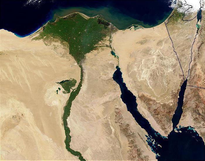
The unity of the African Nile along its entire length gives the river a unique role as a bridge across different climatic zones.
Nile length
Resembling a writhing snake, it spread its loops, according to the latest data, over 6,695 kilometers. The tail “grows” just south of the equator, and the wide head-delta is lowered into the Mediterranean Sea at thirty degrees north latitude. From this distance, the path of the Nile itself exceeds 3,500 kilometers. Thus, the Nile has now won the competition for the right to top the list of world rivers from the Mississippi and the Amazon, although comparisons, especially with the latter, are relative.
Source of the Nile

The hilly terrain east of Lake Tanganyika is noticeably drier than the surrounding plains; The red rocks are covered with bushes and woodlands. A stone's throw from the village of Kikizi in Burundi, several streams form the Luvironza River. It presents a rather pitiful sight, but is considered the most distant full-fledged source from the delta, from which the Nile irrigates a basin of approximately 2,868,000 square kilometers. The Luvironza is one of the upper tributaries of the Tanzanian Kagera, which in turn descends into tropical rainforest, first along the border of Tanzania and Rwanda, and then, turning sharply to the east, separating Tanzania and Uganda.
Related materials:
The longest rivers in the world
At the end of the journey, it flows violently, like a water slide in a water park, into the world's largest Lake Victoria. And the full-fledged Nile emerges from Victoria and from here it steadily moves north, through Uganda and Sudan - to Egypt. So, breaking out of Victoria near the city of Jinja, the main industrial center of Uganda, and passing the equator, it falls into a narrow gorge, where it writhes with rapids.
Sandwiched between the rocks, Big Hapi gains its highest speed and does not lose it until the lake of Victoria's wife, Prince Albert. Having passed the border between Uganda and Sudan, the Nile of Africa receives the name Bahr el-Jebel, and then, merging with the Bahr el-Ghazal River and many smaller tributaries, it becomes the White Nile (Bahr el-Abyad). Meanwhile, the open woodlands give way to endless expanses of savannah, where only rare acacia trees break the even horizon line. The climax comes in Khartoum, where the White Nile connects with the Blue Nile (Bahr el-Azraq), which flowed here from Ethiopia, from Lake Tana. Now there are 330 kilometers left until the last tributary, the Atbara, - it is she, also flowing from the Ethiopian mountains, that is considered the main carrier of the famous black silt, from which an entire civilization grew. Now Neil again changes his temper to a stormy one and writes out a huge S-shaped loop.
Related materials:
The longest river in the world is the Amazon

Here he passes his famous rapids, the first - north of Khartoum, the last (sixth) - near Aswan, where the ascetic mountain ranges suddenly part and a “full-fledged” Valley opens to the eye - a flat hollow, bordered by pink hills at sunset. Surrounded by the Libyan and Arabian deserts, it stretches from here for 840 kilometers - to the delta, the second in area in the world after the Brahmaputrogang. Photos taken from space look like this: a thin green braid, having made several sweeping loops, dissolves into the fawn color of the desert. The population density map will show a thin red stripe crowded on a fertile valley among the sands - snow-white, that is, deserted. From a zoogeographical point of view, the Nile falls into two unequal regions, the boundary between which is crossed by its flow south of the Tropic of Cancer, but north of Khartoum.
To the south is the Ethiopian region, which includes most of Africa, to the north is the Palearctic region, which includes a very large part of Eurasia. A bridge of constant microclimate connecting the spaces from Lake Victoria to the Mediterranean coast. The living conditions there are approximately the same, but they are strikingly different from everything around.
Related materials:
Where do rivers begin and end?
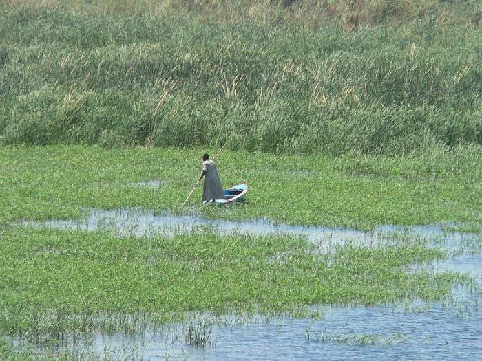
Fauna of the Nile

Along the entire course of the Nile you can find tropical animals and plants that are in no way characteristic of the Palaearctic. Along the entire course of this river, as in the rivers of tropical Africa, there are unique fish of the elephant snout family. The well-known Nile crocodiles and hippos - classic inhabitants of the tropics - could swim into the delta before the construction of the Aswan Dam. In addition, the Nile is the most important axis of movement for migratory birds. Its meridionally oriented bed serves as an excellent reference point for those who, without a compass, want to move strictly south or north: for waders and pelicans, storks and swallows, using the Nile as the Road of Life.
no..I’m hot..I’m sitting in shorts and a T-shirt and eating ice cream...I don’t remember the last time I was cold:)))) my body is like that:)))
beer will freeze at -5....hold it for 5-6 hours
There is a condition when there is severe stress... the so-called cold sweat, when you seem to be shaking from the cold, but you are all wet
This means the depth of the well is more than half a meter. Ground temperature +4 degrees. “warm” water rises and prevents it from freezing on the surface.
if I meet a coachman I know, and even if I don’t know him, I’ll still ask if he freezes when he’s sober...
Do you know what my childhood dream is? To build the largest and best rehabilitation center for animals......as a child, this dream warmed me, but now I understand that it is practically impossible to fulfill it......The topic of animals is the most relevant for me, and at the same time sick at the same time.....My boyfriend, when we just started dating, was afraid to rent an apartment because he claimed that all the animals I met on my way would live with us........Damn, I had to grow up... .sometimes pretend that everything is ok, and look away from his eyes full of tears, although he knows anyway... But I can say with confidence that I will not pass by a dying animal, no matter what the cost.... Many people say that this is stupid, perhaps... but it is.
40% -28.9C.
56% -36C.
Yes, you don’t need to freeze it, but drink it))
In winter, it is best to fill the engine with synthetic oil marked 0W30, 0W40 or 5W40. You can use slightly less frost-resistant, but cheaper semi-synthetic or hydrocracking oil 5W40. Inexpensive mineral oils 10W40, 15W40 and others are optimal for spring, summer and early autumn.
It's not that simple. A water-ethyl solution does not have an exact freezing point. The ice from the water begins to freeze. The alcohol level in the remaining solution increases. The freezing temperature of the solution will already be lower.. And like this, up to the freezing temperature pure alcohol. A hundred and something there..
There is a way to purify moonshine - freezing. Water with all sorts of impurities freezes, and the alcohol is poured off. Only it freezes not in pieces, but in ice porridge.
40-degree temperatures begin to thicken somewhere around -27 degrees. Maybe earlier. Depends on the presence of freezing catalysts in the bottle. Around which ice will freeze. Dye for example... all sorts of impurities.
In Egyptian language, Pharaoh means Sun. There was a tradition of “chronicle rivers Nile" It continues to this day in Egypt. These chronicles were based on the fact that between the Sun and river Nile"There is a constant dialogue." The pharaohs worshiped the Sun. They... are healthy. Children born within 45 years, when the Sun is aging, cannot boast of excellent health. Sacred Records rivers Nile showed that over the course of 45 years, when the Sun was getting younger - going through the period of its youth, the water level was rising. AND...
https://www.site/journal/1966
Monsoon rains become very stormy and fast, and the fertile soil is carried away by the waters of Krishna to the delta region. River Krishna is named after Lord Krishna, the main, eternal being among all living beings who are his particles, through... “Krishna” is translated from Sanskrit as “all-attractive”, this is the original name of God. Like Ganga, Krishna is sacred to Hindus river. Ritual bathing in its waters, according to Hindus, cleanses and washes away all sins. Delta Krishna is one of the most...
https://www.site/journal/146639
I still don’t understand how I started participating there and with whom... After the start of the first stage, we got lost.... River evolved into river my childhood.... The place where we swam.... My partner and I swam inside the island... There seemed to be rubble there... for the fact that we would not make it to the second stage... I was oriented topographically... . I knew how the island was located.. Channels... And according to river I had my bearings.. I knew (from childhood) where the riffles, turns, currents were..... We got lost all night... And in the morning we finally swam out...
https://www..html
And the greatest prophets, awakening people, illuminating the sources where they fall. There are many obstacles on a person's path River Life. There are rocks and rapids that cause suffering; there are creeks and pools that stop you on the Path. There are more... religions have created huge backwaters where huge masses of people swirl in a slow whirlpool. An artificial dam is being created to fence off part of the Rivers- these are churches, temples, monasteries, ashrams... There is no forward movement, no development, there is only the desire to find...
The Nile is not only the main body of water on the African continent, but also one of the longest rivers in the whole world. Receiving the reserves of its tributaries, it is a life-giving force for the population located along its course. This is a priceless treasure of the “dark continent”, over whose waters wars were fought and states united, dams were built and dry lands were revived.
Historical reference
The most important water artery the hottest continent of the planet has been revered by its population since ancient times as a source of life, well-being and prosperity. Thanks to the Nile, today we have the opportunity to get acquainted with Ancient Egypt, its architecture, art, science, wisdom, astronomical knowledge and religion. We can only assume what an important role the Nile played in the formation of the largest civilization that had a huge impact on the life of mankind. As is known, about 20% of the river’s length is located in the territory modern state Egypt. The state of agriculture, the quality of the harvest and its quantity depend on the behavior of the Nile. Thus, the unflooded waters of the Nile mean death for the population. In most cases, the river is always associated with Egypt, where the sacred waters are guarded by the pyramidal tombs of the rulers of the state, the monumental sculpture of the Sphinx, the giant statue of Ramses, and temples dedicated to outstanding pharaohs.

Geographical position
The Nile River is located in Africa and originates from the East African Plateau at an altitude of 1134 m. Not always calm in its flow, but flat, the river passes through the territory of 7 countries, simultaneously uniting them with its waters. Among them are the equatorial and multilingual Uganda, the country of wild Kenya, the unique Tanzania, the birthplace of humanity Ethiopia, the center of tropical epidemics, the desert Republic of Sudan and the contrasting Egypt. The great river has been feeding the territory of these states for about 3 million years, saving the population from hunger and drought. Such historical centers of Egypt as Cairo, Luxor, Aswan, Giza and Alexandria, and the capital of Sudan, Khartoum, grew up on it.
Climatic conditions
With a length of 6852 km, the Nile crosses the following equatorial, subequatorial, tropical and subtropical. Most along its route, which is more than 3000 km, it passes through the territory of the largest desert in the world - the Sahara.
The river's feeding regime directly depends on climatic conditions. The Nile is the annual flood of the summer and winter period. The reason is associated with the rainy season in equatorial latitudes, where one of its tributaries originates. Thanks to this type of precipitation, the great river is full-flowing and fast-flowing. At this time of year, the Nile can overflow its banks, inundating populated areas and causing floods.
In winter it is replenished with the waters of the White Nile, and in summer - with the Blue Nile. Low water (most low level water) falls in the month of May. The temperature indicators of the water of a hydrological object vary depending on the type of climate. The average summer period is plus 26 o C, winter - plus 18 o C.
Source of the Nile
Many researchers disagreed with each other about where the source of the Nile was located. Inaccessible jungle, hilly terrain with ledges and rapids, mosquitoes and crocodiles became an obstacle to a thorough study of the hydrological object. The mystery became clear only in the middle of the 18th century, thanks to the efforts of the London Geographical Society and the determination of its employees - the officer, traveler John Speke and river explorer Samuel Baker.

The official opening began great river the year is considered to be 1864. The peculiarity of the Nile is that it has not one source, like most rivers on the planet, but two. The main tributary with geographic coordinates (0°N, 33°E) originates in the equatorial latitudes of Uganda, carrying its waters into Lake Victoria, and emerges as the stormy Kageroi River. Overcoming ledges and, at the same time, replenishing fresh water reserves in the lakes of the mainland, the right tributary emerges as the White Nile onto the flat surface of the African continent.

The birthplace of the second source is considered to be the area where the Blue Nile emerges. The confluence of two deep tributaries occurs near the capital of Sudan - the city of Khartoum. Following in a northern direction, the full-flowing river carries life force in a single channel through the desert territory into the Mediterranean Sea, forming a huge delta on its way.
Mouth of the sacred river
The place where the Nile River flows has geographical coordinates(31 o N, 30 o E). The shape of the mouth of the reservoir is no less unique than the history of the search for the source of the river. Thanks to river sediments, it forms a huge triangle, resembling the Greek letter “delta”. 160 km from the capital of Egypt, Cairo, two large navigable branches are formed - Damietta and Rashid, as well as many small channels.

It is the Nile Delta that is considered the most fertile section of the famous river. A unique natural formation stretches for more than 240 km along the southern shores Mediterranean Sea. This is the most populated part of Egypt and the entire Nile bed. The scale of river sediment is simply stunning; its size is equal to the area of the entire Crimean peninsula.
Flora and fauna
Vegetable and animal world The area where the Nile is located changes in its species composition, in the direction of the river's flow. The richest areas of the zone are savannas and light forests, less expressive areas are deserts and semi-deserts.
The aquatic world is saturated with such representatives as the Nile crocodile, polyfin, hippopotamuses and a variety of fresh fish. About 300 species of birds nest on the banks of the river, many migratory and wintering representatives. But flamingos, pelicans, and herons especially stand out.

The most interesting flora and fauna of the delta and Nile Valley are papyrus, date palms, acacias, oleander, citrus fruits, reed thickets, cattails and ferns, cultivated vegetation. Here you can find representatives of the fauna such as turtles, hippopotamuses, artiodactyls, reptiles and many insects. The leaders among the animal world are birds. The Nile River basin is simply a salvation for the established flora and fauna.
For any tourist, getting to the area where the Nile is located will not be a problem. The most exciting and at the same time dangerous is traveling along the river. The source of the Nile is interesting for its inaccessibility. The place where the Nile River flows captivates with rich colors and amazing objects.
The distance between Moscow and the capital of Egypt on the map is more than 4000 km. For air transport in a straight line - about 3000 km and 4 hours of travel. Flights are organized by 8 airlines, where there are direct flights and with transfers in Istanbul. But where the Nile is most interesting is up to the tourist to decide. Not everyone likes the humid and hot jungle, some love warm sand, heat and pyramids.
Features of the great river
The main difference between the Nile and most rivers on the planet is the direction of the flow - from south to north. The nature of the river depends on the terrain. In the upper section it looks like a mountain river - seething and noisy. The hilly terrain and heavy rainfall help the river to develop its main channel with its flow. Downstream sacred river calm, quiet and navigable. Here, according to all the characteristics, we see that the object is the flat Nile River. Continent Africa, its homeland, is hot and deserted at its confluence, and humid at its source.
The section of the river with rapids and waterfalls is called the Victoria Nile, the calm Albert Nile stretches until the tributaries reunite into one channel, the most swampy section is in the Bahr el-Jebel. Forming six rapids, the river created many problems with navigation for centuries, so the construction of a reservoir was simply a necessity. It solved the issue of transport movements and at the same time became a salvation for arid regions.
Unlike the Amazon, the Nile flows through the desert regions of the “dark continent”, but does not lose its full flow. It brings a lot of silt deposits, which are organic fertilizer, thereby doubling its advantage.

Tourist opportunities
The Nile is not just a hydrological feature of the planet. This is a ready-made natural route stretching from the equator to the tropical borders. Its tourism opportunities are endless. For those who like to see more and faster, cruise trips along the river with stops in famous historical cities have been created:
- Cairo attracts with museums and ancient Egyptian art, pyramids and statues;
- Alexandria captivates with legends, forts and beaches;
- Thebes - temples and honorable age;
- Aswan - palm islands and the standard of living of Egypt;
- Sudanese Khartoum - ensembles of palace architecture.
Those who like to explore the natural resources along the river may spend more time, but as a result they will get a brighter impression.


